


Parking Cimetière de Le Thillot - Chaillon - Col de Foigneux - La Revanche - Pic des Corbeaux et retour

patrickbeyrath
User
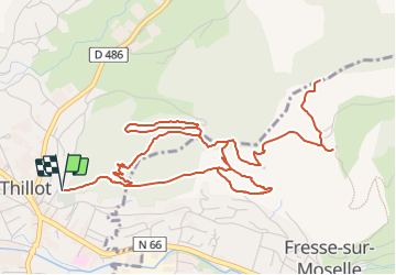

Length
7.9 km

Max alt
776 m

Uphill gradient
345 m
Km-Effort
12.5 km

Min alt
511 m

Downhill gradient
344 m
Boucle
Yes
Creation date :
2023-08-01 09:51:19.851
Updated on :
2023-08-04 07:37:40.837
2h50
Difficulty : Medium

FREE GPS app for hiking
 SityTrail
IGN / Geographical institutes
SityTrail Plus
The world is yours!
About
Trail Walking of 7.9 km to be discovered at Grand Est, Vosges, Le Thillot. This trail is proposed by patrickbeyrath.
Positioning
Country:
France
Region :
Grand Est
Department/Province :
Vosges
Municipality :
Le Thillot
Location:
Unknown
Start:(Dec)
Start:(UTM)
333067 ; 5305410 (32T) N.
Comments